Austrian Positioning Service (APOS)
table of contents
APOS is the GNSS satellite positioning service of the BEV. It utilizes GNSS signals, processes them centrally, and provides derived parameters to improve the accuracy of satellite-based measurements.
Every APOS reference station is determined with centimeter-level coordinate accuracy and is equipped with high-quality geodetic GNSS equipment.
The following products are offered:
- APOS-PP: Raw station data from the GPS, GLONASS, GALILEO, and BEIDOU systems in the international standard RINEX format, provided by approximately 40 APOS GNSS reference stations for post-processing applications.
- APOS Real Time: Individual correction data provided either as a Virtual Reference Station (VRS) for the GPS, GLONASS, and GALILEO systems, or according to the Master Auxiliary Concept (MAC) for GPS and GLONASS, for real-time applications.
Two accuracy classes are distinguished:- APOS-RTK: Centimeter-level accuracy for high-precision applications using multi-frequency phase measurement devices.
- APOS-DGPS: Sub-meter accuracy for GIS and navigation applications using phase-smoothed code measurement devices.
- APOS RAW: Real-time access to the raw data stream of the APOS GNSS reference stations.
Current information regarding the operating status of APOS products can be found here.
Suitability / Usage
- Basic/Control, cadastral, and scientific surveying
- Agriculture and forestry:
Since February 1, 2021, the Federal Office of Metrology and Surveying (BEV), in cooperation with the Federal Ministry of Agriculture and Forestry, Climate and Environmental Protection, Regions and Water Management (BMLUK), has made the RTK correction signal APOS Real Time available free of charge for agricultural and forestry use. Click here for further information. - Construction and engineering surveying
- Aerial surveys (photogrammetry)
- Geological and geophysical point surveys
- GIS data collection
- Stakeout and route planning
- Machine control and guidance
Data Type
3-D coordinates in the ETRS89 and MGI systems.
Product List and Prices
| APOS-PP | |
|---|---|
| APOS-PP (Data rate 1 second) | Free of charge |
| APOS-PP (Data rate 30 seconds) | Free of charge |
| APOS Real Time | Price in € |
| APOS Real Time - Setup fee (one-time) | 50,00 |
| APOS-RTK (cm-accuracy) - per second | 0,0015 |
| APOS-RTK (cm-accuracy) - Daily flat rate | 20,00 |
| APOS-RTK (cm-accuracy) - Monthly flat rate | 200,00 |
| APOS-DGPS (dm-accuracy) - per second | 0,00015 |
| APOS-DGPS (dm-accuracy) - Daily flat rate | 2,00 |
| APOS-DGPS (dm-accuracy) - Monthly flat rate | 20,00 |
| APOS RAW | Price in € p.a. |
| Total Austria | 50 000,00 |
Note: The standard fees of the BEV cover data costs only. Connection fees are not included in the charges billed by the BEV; these are based on the data transfer tariffs of the respective provider and are billed separately by them.
APOS Real Time Mountpoints
| Name | Format | Mode | GPS | GLO | GAL | Transformation Grids | Validity |
|---|---|---|---|---|---|---|---|
| APOS-DGPS | |||||||
| APOS_DGPS | RTCM 2.3 | VRS | X | X | Until revoked | ||
| APOS-RTK | |||||||
| APOS_VRS | RTCM 2.3 | VRS | X | X | Until revoked | ||
| APOS_VRS3 | RTCM 3.1 | VRS | X | X | GIS-Grid | Until revoked | |
| APOS_NET3 | RTCM 3.1 | MAC | X | X | GIS-Grid | Until revoked | |
| APOS_VRS32_MSM | RTCM 3.2 MSM51) | VRS | X | X | X | GIS-Grid | Until revoked |
| APOS_VRS32_MSM_3D2 | RTCM 3.2 MSM51) | VRS | X | X | X | GIS-Grid | Until revoked |
| APOS_VRS32_GRID2021 | RTCM 3.2 MSM51 | VRS | X | X | X | GIS-Grid 2021 | Until revoked |
1) MSM - Multi Signal Message
2) See Quality, "3D Interpolation"
APOS Real Time Billing
Setup fees are charged once with the first invoice and are payable per account.
Second-based, daily, and monthly flat rates are invoiced monthly and charged per commenced unit, depending on the selected flat-rate model:
- For the second-based rate, the individual connection times within a calendar month are summed to the exact second and charged at the per-second tariff.
- The daily flat rate is charged for each calendar day on which at least one system login occurred.
- The monthly flat rate is charged for each calendar month in which at least one system login occurred.
Explanations:
A calendar month or calendar day refers to Coordinated Universal Time (UTC). An invoiced calendar month or calendar day therefore begins at 00:00:00 UTC and ends at 23:59:59 UTC. During Central European Summer Time (CEST), CEST = UTC + 2 hours; during Central European Time (CET), CET = UTC + 1 hour.
The connection time is defined as the duration between system login and system logout. Billing occurs even if, for reasons caused by the user, no APOS correction data can be processed on the rover side.
Any change or cancellation of the tariff model (flat rate) becomes effective on the first day of the following month.
Terms of Use
- APOS-PP: The standard license CC BY 4.0 applies to this product.
- APOS Real Time: A separate account is required for each device used with APOS Real Time. Simultaneous logins of multiple devices using the same account are not permitted.
- APOS RAW: The standard fee includes internal use of the raw data streams from all Austrian APOS GNSS reference stations.
- Detailed information on the BEV’s terms of use can be found under Price Information.
Delivery Units
- APOS-PP: Data rates of 1 second and 30 seconds. Data is available for download for 60 days (1-second interval) or 2 years (30-second interval) after recording. Thereafter, data is available only in the 30-second interval as 24-hour files upon request, subject to availability.
- APOS Real Time: Data rate of 1 second.
- APOS RAW: Data rate of 1 second.
Delivery
- APOS-PP: Download via Geoportal.
- APOS Real Time: Provision of correction data via mobile internet (NTRIP3)).
- APOS RAW: Data connection via NTRIP3) client software on the customer side.
3) NTRIP stands for Networked Transport of RTCM via Internet Protocol and is a method developed by the Federal Agency for Cartography and Geodesy (BKG, Frankfurt am Main) for providing GNSS data streams over the internet.
Technical Requirements for the Use of APOS Real Time:
- VRS- or MAC-capable GNSS receiver with a mobile internet module (2G or higher)
- Consideration of the mobile internet network coverage of the provider (2G or higher)
- Implementation of an NTRIP client program (function available in current device types or retrofittable)
- Access after registration via an individual account
- Automated transmission of the receiver’s approximate position to the APOS service center for calculation of an individual VRS (or MAC network information)
- Uninterrupted simultaneous reception of at least five geometrically well-distributed GNSS satellites
- Observance of the basic principles and limitations of GNSS measurement methods, such as shadowing, satellite geometry, multipath propagation, jammers, and mobile internet coverage
Further information regarding measurement equipment and configuration of end devices is provided by equipment distributors.
Data Format
- APOS-PP: RINEX Version 3.x; RINEX Version 2.10 for data prior to October 25, 2022.
- APOS Real Time: RTCM 2.3 (VRS), RTCM 3.1 (VRS, MAC, Transformation Grids), and RTCM 3.2 MSM5 (VRS, Transformation Grids).
- APOS RAW: RTCM 3.2 MSM5.
- Instructions (PDF, 88 KB) (PDF, 88 KB) for converting RINEX data are available.
Online Access
- APOS-PP: Data freely available; no registration required
- APOS Real Time: Registration required; activation within 48 hours (on working days)
- APOS RAW: Registration required; activation after notification of a fixed IPv4 address on the customer side
Copyright
The analog and digital products of the BEV are protected under the Copyright Act (UrhG), Federal Law Gazette No. 111/1936, as amended. Furthermore, the digital products of the BEV stored in databases are subject to database protection pursuant to §§ 76 ff UrhG. The Federal Office of Metrology and Surveying holds the exclusive right to grant exploitation rights to this data to third parties. With regard to its databases, the BEV holds exclusive usage rights pursuant to §§ 40f–40h UrhG and the sui generis right pursuant to §§ 76c–76e UrhG.
Contact and Order
Contact
For questions regarding registration, ordering, activation, and billing, please contact Customer Service at kundenservice@bev.gv.at or +43 1 21110-822160.
Temporary technical disruptions cannot be completely ruled out. The APOS service team endeavors to remedy system malfunctions promptly during APOS service hours on working days, Monday to Thursday from 8:00 AM to 4:00 PM and Friday from 8:00 AM to 12:00 PM.
Technical Questions
APOS-Hotline: +43 676 8210 1111
Operating Status: APOS - Operation
Order
APOS-PP:
- RINEX data can be downloaded without registration via the BEV Geoportal.
APOS Real Time:
- Registration as a BEV customer is required; access to APOS services requires free registration via the BEV Portal.
- After registration and receipt of a customer number, please submit the order form APOS_Real_Time-GV_007_11 (PDF, 868 KB) to Customer Service.
- Access data will be provided within two working days.
APOS RAW:
- For a data connection to the Austrian APOS GNSS reference stations, please submit the order form APOS_Raw-GV_008_10 (PDF, 1008 KB) (PDF, 853 KB) to Customer Service.
Download
Descriptions / Interfaces
Systeme Landesvermessung 2015 (PDF, 23 MB)
Auswirkung der Sonnenaktivität auf GNSS-Messungen mit APOS (PDF, 80 KB)
„Die befleckte Sonne" (Autor: Professor Lambert Wanninger, TU Dresden)
Brochures
Austrian POsitioning Service - Broschüre (PDF, 2 MB)
Austrian POsitioning Service - Broschüre englisch (PDF, 2 MB)
Austrian POsitioning Service Landwirtschaft - Broschüre (PDF, 2 MB)
Austrian POsitioning Service Landwirtschaft Fahrspurplanung - Broschüre (PDF, 3 MB)
Quality
Data Source
GNSS Reference Stations
Data Acquisition and Processing
Since January 1, 2004, the APOS GNSS reference stations have represented the highest level of the European reference system ETRS89 (European Terrestrial Reference System 1989) in Austria and comply with the EUREF Class A specification (coordinate repeatability better than ±1 cm).
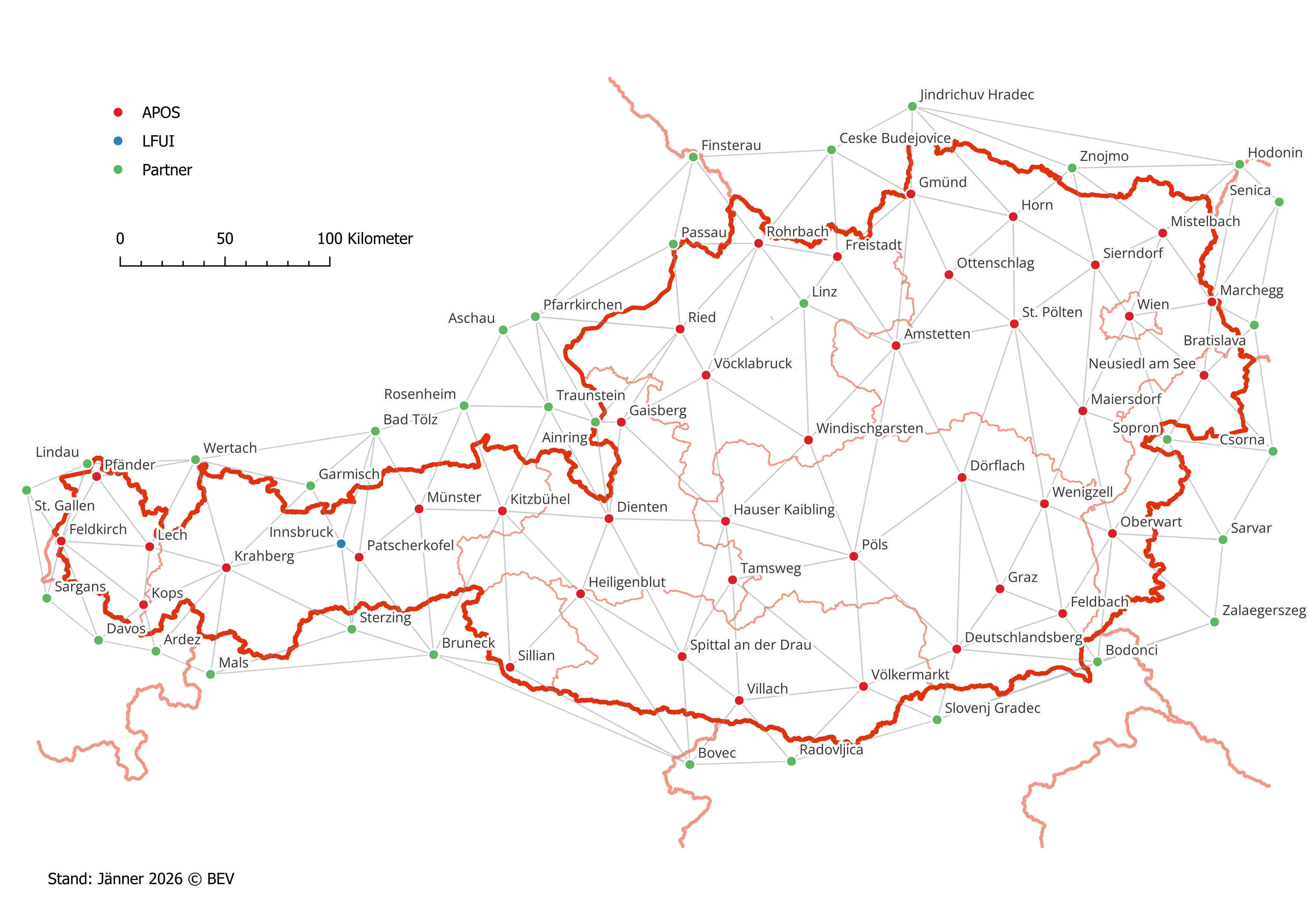
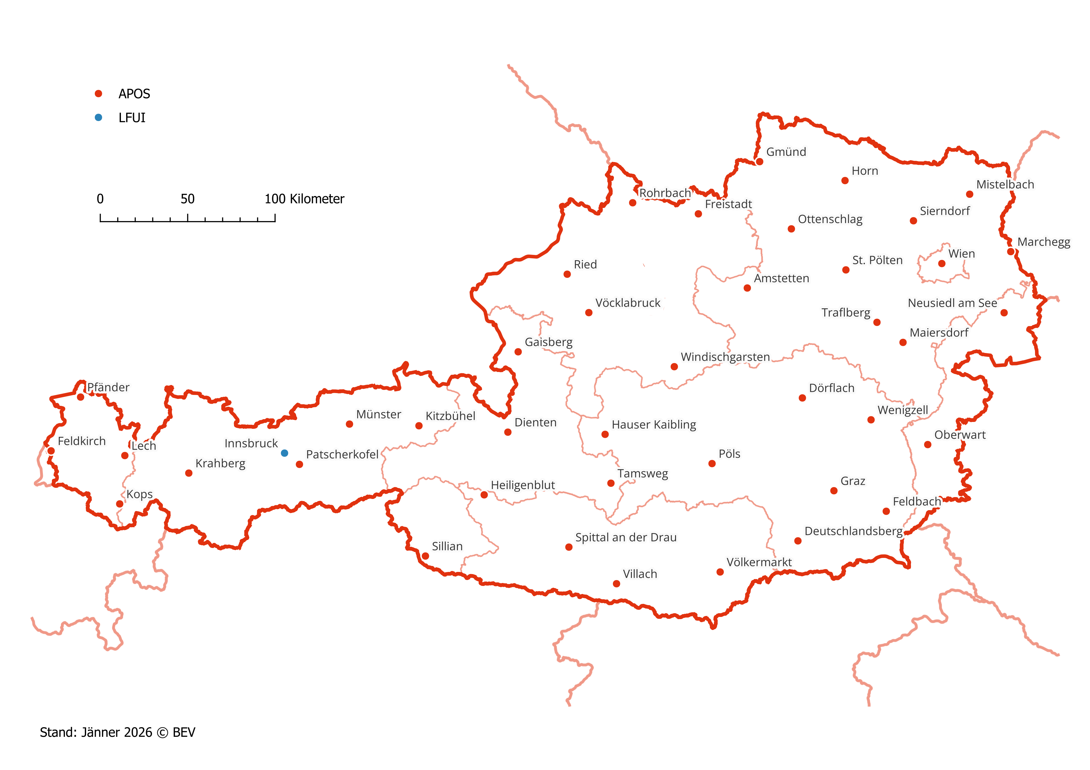
In cooperation with the University of Innsbruck (LFUI), the GNSS reference stations listed below are operated permanently (see Fig. 1 and Table 1).
Satellite signals from the GPS, GLONASS, GALILEO, and BEIDOU systems are received, stored at the GNSS reference stations and forwarded to the APOS service centre for further processing. The three-dimensional ETRS89 coordinates of these stations are subject to continuous monitoring.
(See Figure 1: APOS GNSS Reference Stations in Austria. Photo: BEV)
| APOS GNSS Reference Stations | |||||||||||||||||||||||||||||||||||||||||||||||||||||||||||||||||||||||||||||||||||||||||||||||||||||||||||||||||||||||||||||||||||||||||||||||||||||||||||||||||||||||||||||||||||||||||||||||||||||||||||||||||||||||||||||||||||||||||||||||||||||||||||||||||||||||||||||||||||||||||||||||||||||||||||||
|---|---|---|---|---|---|---|---|---|---|---|---|---|---|---|---|---|---|---|---|---|---|---|---|---|---|---|---|---|---|---|---|---|---|---|---|---|---|---|---|---|---|---|---|---|---|---|---|---|---|---|---|---|---|---|---|---|---|---|---|---|---|---|---|---|---|---|---|---|---|---|---|---|---|---|---|---|---|---|---|---|---|---|---|---|---|---|---|---|---|---|---|---|---|---|---|---|---|---|---|---|---|---|---|---|---|---|---|---|---|---|---|---|---|---|---|---|---|---|---|---|---|---|---|---|---|---|---|---|---|---|---|---|---|---|---|---|---|---|---|---|---|---|---|---|---|---|---|---|---|---|---|---|---|---|---|---|---|---|---|---|---|---|---|---|---|---|---|---|---|---|---|---|---|---|---|---|---|---|---|---|---|---|---|---|---|---|---|---|---|---|---|---|---|---|---|---|---|---|---|---|---|---|---|---|---|---|---|---|---|---|---|---|---|---|---|---|---|---|---|---|---|---|---|---|---|---|---|---|---|---|---|---|---|---|---|---|---|---|---|---|---|---|---|---|---|---|---|---|---|---|---|---|---|---|---|---|---|---|---|---|---|---|---|---|---|---|---|---|---|---|---|---|---|---|---|---|---|---|---|---|---|---|---|---|---|---|---|---|---|---|---|---|---|---|---|---|---|---|---|---|---|
|
|||||||||||||||||||||||||||||||||||||||||||||||||||||||||||||||||||||||||||||||||||||||||||||||||||||||||||||||||||||||||||||||||||||||||||||||||||||||||||||||||||||||||||||||||||||||||||||||||||||||||||||||||||||||||||||||||||||||||||||||||||||||||||||||||||||||||||||||||||||||||||||||||||||||||||||
Table 1: List of APOS GNSS Reference Stations (approximate ETRS89 coordinates, EPSG:4937)
APOS-PP
RINEX data is available for the Austrian APOS GNSS reference stations (see Fig. 1 and Tab. 1). The ETRS89 station coordinates visible in the header of the RINEX files are approximate coordinates.
APOS Real Time
APOS Real Time is based on the implementation of an Austria-wide and cross-border station network (see Fig. 2). Cooperation with all surveying authorities (station operators) of neighboring countries, realized since early 2009, guarantees increased system availability combined with enhanced performance up to the national borders. APOS thus provides homogeneous 3D coordinates in the ETRS89 system in real time throughout Austria.
APOS RAW:
Raw data streams are available for the Austrian APOS GNSS reference stations (see Fig. 1 and Tab. 1).
General Positional Accuracy
The accuracy achievable with APOS depends on the application and factors such as measuring equipment, measurement duration, point environment, and evaluation software. Under optimal conditions, the following accuracies can be achieved:
| APOS Product | Positional Accuracy | Height Accuracy | ||
|---|---|---|---|---|
| ETRS891) | MGI2) | ETRS891) | MGI2) | |
| APOS-PP | ± 1,0 cm | ± 1,0-2,0 cm | ||
| APOS Real Time: APOS-DGPS | ± 0,5 m | ± 1,0 m | ||
| APOS Real Time: APOS-RTK | ± 1,5 cm | < 15,0 cm | ± 4,0 cm | < 15,0 cm |
| APOS RAW | ± 1,0 cm | ± 1,0-2,0 cm | ||
1) Genauigkeit: 1 Sigma
2) Valid for those mountpoints that transmit transformation grids (see Product List and Prices)
Transformation Grids
Transformation grids are packaged in RTCM 3 message 1023 and delivered by APOS-RTK. Based on a densely interpolated grid network describing deviations between the European reference system ETRS89 and the Austrian national surveying system MGI, a uniform online transformation from ETRS89 to MGI with decimeter accuracy can be performed in real time throughout Austria.
Different transformation grids are provided depending on the mountpoint (see Product List and Prices):
- GIS Grid: Uses the BEV GIS Grid and a separate height grid (mesh size 30″ × 45″), derived from approximately 28,000 identical points of the national control point network (1st–5th order). Not suitable for cadastral applications.
- GIS Grid 2021: Uses the BEV GIS Grid 2021 and the height grid plus Bessel ellipsoid (mesh size 5″ × 7″), derived from approximately 56,000 identical points. Not suitable for cadastral applications
"3D-Interpolation"
For the mountpoint APOS_VRS32_MSM_3D, APOS correction data is additionally processed to mitigate problematic meteorological influences.
In particular, significant height differences between the rover and the reference stations (e.g. alpine regions) can result in varying relative humidity conditions, potentially causing deviations of up to several decimeters, especially in summer. Use of this mountpoint can improve height accuracy at the rover, although system-related degradation of horizontal positional accuracy of up to 100% may occur simultaneously
Continuation / Update
The dataset is available nationwide for the whole of Austria.
General Completeness
APOS-PP – Availability:
The APOS GNSS reference stations are in continuous operation and record observation data (code and phase measurements from the GPS, GLONASS, GALILEO, and BEIDOU systems on at least two frequencies) in the international RINEX 3.x format. Depending on the data rate, this data is available for download for 60 days or 2 years after recording (see Product List and Prices, Delivery Units). RINEX files with a 30-second data interval are, however, permanently archived as 24-hour files.
APOS Real Time / APOS RAW – Resilience and Reliability:
Comprehensive redundancy and monitoring concepts ensure the highest possible resilience of the APOS Real Time and APOS RAW services. Key elements include:
- Monitoring of APOS GNSS reference stations, including remote power management, use of uninterruptible power supplies (UPS), and real-time coordinate monitoring
- Redundant design of the APOS service center infrastructure
- Calculation of correction parameters based on a nationwide station network (VRS, MAC), ensuring continued operation even in the event of isolated station failures
- Continuous system verification through test measurements at monitoring stations distributed throughout Austria
Force Majeure
Force majeure or other unforeseeable obstacles within the sphere of responsibility of the BEV release it from compliance with the agreed obligations. Operational disruptions within the contractual partner’s domain are also considered force majeure and release the BEV from the provision of services for the duration of the impediment, without giving rise to any claims for price reductions by the contractual partner.
Auswirkung_der_Sonnenaktivitaet_auf_GNSS-Messungen mit APOS (PDF, 80 KB)
Spatial Reference
Reference System
ETRS89, Cartesian coordinates X, Y, Z 3D (EPSG:4936)
After transformation via transmitted transformation grids:
MGI, longitude and latitude (2D, EPSG:4312)
Austrian orthometric heights = MGI heights (EPSG:5778)
combined: MGI, Cartesian coordinates X, Y, Z 3D (EPSG:9266)
Note: The transformation provides an approximate position for GIS applications - not suitable for cadastral applications!
Projection into plane coordinate systems (UTM, Gauss–Krüger, Lambert, etc.) is performed on the user side.
Geodetic Datum
ETRS89 realization: ETRF2000 (Epoch 2002.56), solution Austria 2002.