Remote Sensing
table of contents
Products
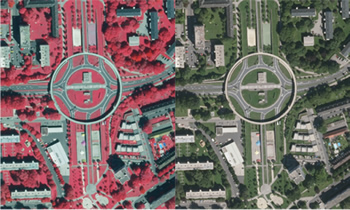
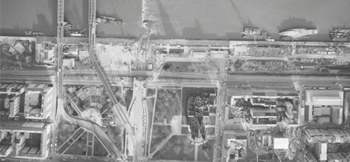
Aerial Image
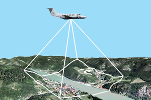
Aerial images are pictures taken from aircrafts during flight, which are subject to special quality criteria.
Between 1949 and 2009 the BEV produced, depending on the planned application, analogous aerial images with black and white, color positive, color negative or infrared color positive films with different picture formats, focal length of the lens, flight heights, picture scales and overlap.
The flights generally depended on the update cycles of the products of the BEV and were made approximately every 5 - 7 years over the same area.
Since the year 2010 the BEV has provided digital aerial images which are taken with a digital large format aerial camera. We record the color channels RGB (red, green and blue) and NIR (near-infrared) as well as PAN (panchromatic). The whole Austrian territory is covered in a 3-year cycle.
All these aerial images depict spatial objects with the highest precision in a central projection. Deformations due to the central perspective depend mainly on the focal length of the lens and the topography of the landscape.
Availability and Up-to-dateness Aerial Image Archive
All aerial images are available at the aerial image archive of the BEV (Customer Center).
This archive comprises approximately 450.000 analogous images for the years 1949 - 2 009, which cover the federal territory within a period of 5 - 7 years. Additionally since 2010 annually an average of 60.000 digital aerial images, which covers the federal territory every 3 years, have been added.
The documentation of the single flight projects is available online at www.bev.gv.at (BEV Shop PLUS). In the course of the research at the online shop the respective aerial images can be visualized as quicklooks.
The Following Products are Available:
Digital Aerial Image
- till flight year 2009: digital aerial image color, digital aerial image monochrome (scanned from film)
- as of flight year 2010: digital aerial images (RGB+NIR) with orientation data (digitally taken)
Aerial Image Reproduction
- for all flights till 2009: analogue aerial images, full picture respectively section enlargement as PDF or on paper
- as of light year 2010: image data in analogue form are just available via "Orthophoto aktuell PDF"
Flight Location Map
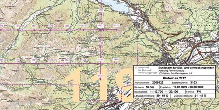
One of the most important parts of the aerial image archive of the BEV are the flight location maps, which are necessary to locate the position of the images for an area of interest.
Flight location maps are overviews based on the respective flight project and represent the covered areas. Depicted are the flight lines as well as the center of the images. In addition we list the metadata of the image flight (flight title, archive number, focal length, flight date, scale, film type, overlap long track and cross track).
Availability
Flight location maps are available for each flight since 1949 at the aerial image archive of the BEV.
The flight location maps are available as free-of-charge downloads in the format PDF (as of flight year 2003) and as SHP-file (as of the flight year 2011).
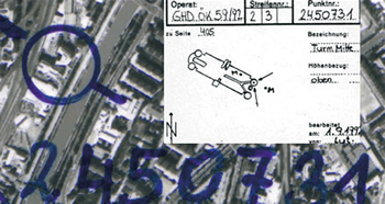
Metadata of Aerial Images
The aerial image archive of the BEV contains not only the original images but also the necessary basis for the photogrammetric applications.
Amongst the indispensable working aids for the technical evaluation of aerial images are:
- Control point coordinates
- Control point sketches
- Control point overview
- Working copies
- Working slides
- Orientation data
- Calibration protocols
Metadata of flights since 2010 are directly connected to the aerial images.
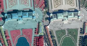
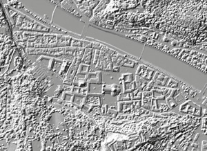
Orthoimage
An orthoimage is, in contrast to an aerial image, a deformation-free and true to scale image of the surface of the earth. The deformations resulting from the topography of landscape in the central projection are compensated mathematically. The basis for the calculation forms the Digital Terrain Model.
Orthoimages up-to-date
The present up-to-date stock of colored orthoimages was compiled from the digital aerial images (RGBI). These orthoimages are produced with a ground sampling distance of 20 cm. It is possible to derive products in different resolutions from these orthoimages.
Availability and Up-to-dateness
Up-to-date orthoimages are available for the whole Austrian territory. The updating cycle was fixed to 3 years. For the coverage status please see www.bev.gv.at.
Delivery is possible as "Orthophoto aktuell" (digital) and "Orthophoto aktuell PDF".
Orthoimage historical
Orthoimages that are not derived from the latest flights (Orthophoto aktuell), are listed as historical orthoimages. This also includes the older versions of the color orthoimages (true and false color / colorinfrared
orthoimages) as well as the BW orthoimages which are not available area wide on a regular basis.
Since 2000 the historical color orthoimages have been produced from multipurpose flight color aerial images, the images were taken with a middle image scale of 1:15 000 and a focal length of 21 respectively 30 cm. The ground sampling distance of these orthoimages amounts to 25 cm.
Since 2010 historical orthoimages from digital flights have been produced with a ground sampling distance of 20 cm. Historical BW orthoimages were derived from monochrome images with a scale of 1:30 000. The monochrome orthoimages were produced with a ground resolution of a pixel size of 50 cm.
Availability
Historical orthoimages are available for the whole Austrian territory.
Delivery
Orthoimage historical (color, monochrome) - digital, PDF
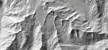
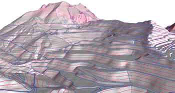
Digital Terrain Model
The Digital Terrain Model (DGM) describes the terrain (natural surface without growth) by using measurements that are located in a regular grid having georeferenced positions and heights (height grid). Additional terrain structures such as edges and single significant points complete the regular height grid
and give detailed information about the Austrian topography.
Updating
The DGM has no fixed intervals for updating. The height data are updated continuously. Large-scale changes in nature are updated permanently. The data for the free-of-charge products are updated once a year.
Availability
At the moment we have a terrain model with a grid that is interpolated to 10 meters and has integrated structure information for the whole of Austria, which is used to derive additional products.
Height Grid
The DGM is used to interpolate grids with an optional size. This height grid is used to calculate orthoimages and as representation of the landscape. Grid size 5 m, 25 m (as well as free-of-charge 50 m, 100 m, 250 m, 500 m)
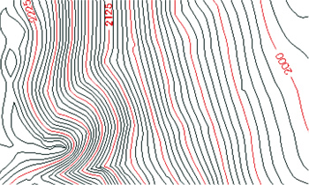
Contour Lines
The DGM is used to derive contour lines (lines of constant height) and depict them as vector data. The lines are interrupted by height labels. Equidistance 5 m, 10 m, 20 m
Structure Information (with / without height grid)
Structure information is besides of the measured grid the most important part of the original measurements of the DGM. They describe the details of the earth surface by means of edges and single significant points and are considered especially when derived products are prepared.
Digital Surface Model
The Digital Surface Model (DOM) describes the surface of the earth with all the objects on it by using points that are located in a regular grid and have georeferenced positions and heights (height grid). Other than the DGM it includes the vegetation and building surface.
The BEV-DOM is created from the digital aerial images by means of an automatic image matching process.
Updating and Availability
Since the end of the area-wide aerial image flights 2013 - 2015 we have had area-wide data. The interval for updating the DOM is the same as for the procurement of the digital aerial images. Thus the whole area of Austria is updated within 3 years.
Standard Charges
| Aerial image digital | Price in € per aerial image |
|---|---|
| Scanned analogue aerial images - till flight year 2009 | 25,00 |
| Aerial images from digital flights - as of flight year 2010 | 25,00 |
| Aerial image analog Aerial image as well as full image enlargements (till flight year 2009) |
Price in € per full image |
| 1:1 - PDF | 10,00 |
| 1:2 - PDF | 16,00 |
| 1:3 - PDF | 22,00 |
| 1:4 - PDF | 35,00 |
| 1:5 - PDF | 52,00 |
| 1:6 - PDF | 72,00 |
For the enlargement on paper we charge an additional 100% (of the PDF-Standard charges).
| Aerial image detail enlargement (till flight year 2009) | Price in € per sheet |
|---|---|
| Format A4 - PDF | 20,00 |
| Format A3 - PDF | 25,00 |
| Format A2 - PDF | 30,00 |
| Format A1 - PDF | 50,00 |
| Format A0 - PDF | 70,00 |
For the enlargement on paper we charge an additional 100% (of the PDF-Standard charges).
| Aerial image preview copy | Price in € per sheet |
|---|---|
| Preview copy of the archive copy - PDF | 7,50 |
| Flight location map | Price in € per flight set |
|---|---|
| Flight location map | Free-of-charge |
| Flight location map - PDF | Free-of-charge |
| Photogrammetric basis (till flight year 2009) | Price in € per sheet |
|---|---|
| Working copy | 7,50 |
| Control point (coordinate) + control point sketch | 3,00 |
| Calibration protocol | Free-of-charge |
| Orientation data | Free-of-charge |
| Orthoimage digital - Orthoimage up-to-date | Price in € per km² |
|---|---|
| Orthoimage color resolution 0,20 m | 3,00 |
| Orthoimage color resolution 0,50 m | 1,00 |
| Orthoimage color resolution 1 m | 0,20 |
| Orthoimage color resolution 2 m | 0,05 |
| Orthoimage historical | Price in € per km² |
| Orthoimage monochrome resolution 0,50 m | 1,00 |
| Orthoimage color resolution 0,20 m or 0,25 m | 3,00 |
| Orthoimage analog - Orthoimage up-to-date | Price in € per sheet |
| Format A4 - PDF | 2,50 |
| Format A3 - PDF | 3,75 |
| Format A2 - PDF | 5,00 |
| Format A1 - PDF | 10,00 |
| Format A0 - PDF | 15,00 |
| Orthoimage historical | Price in € per sheet |
| rthoimage color in sheet line DKM 1:2 000 - PDF | 10,00 |
| Orthoimage monochrome in sheet line ÖLK 1:10 000 - PDF | 10,00 |
Digital Terrain Model (DGM)
| DGM height grid | Price in € per km² |
|---|---|
| Grid width 5 m | 3,00 |
| Grid width 25 m | 1,00 |
| Grid width 50 m | Free-of-charge |
| Grid width 100 m | Free-of-charge |
| Grid width 250 m | Free-of-charge |
| Grid width 500 m | Free-of-charge |
| DGM height contour lines | Price in € per km² |
| Equidistance 5 m | 2,00 |
| Equidistance 10 m | 1,00 |
| Equidistance 20 m | 0,25 |
| DGM structure and form lines | Price in € per km² |
| Structure information | 4,00 |
| Structure information with height grid 5 m | 5,00 |
Digital Surface Model (DOM)
| Digital Surface Model (DOM) | Price in € per km² |
|---|---|
| Grid width 0,5 m | 6,00 |
General Terms and Conditions
The terms of delivery and payment as well as the copyright notice are set out in the current Terms and Licensing Conditions of the BEV.
Standard Charges and Licensing Conditions
The price and licensing conditions for the products of the BEV are regulated in the "Standard Charges and Licensing Conditions of the BEV". The current version is published in the "Amtsblatt für Vermessungswesen" (official journal for surveying) and can be found on www.bev.gv.at.
Potential Applications
Based on the product features it is possible to provide multiple applications:
Aerial images
- Aerial image interpretation (amongst others time series)
- Photogrammetric analysis
- Orthoimage production
- Documentation
- Agriculture and forestry
- Cadaster
- Topography
- Environmental protection
- Disaster operation
- Images for decoration
Orthoimages
- Planning basis
- Maps and plans
- Basic information for additional data capture
- Basis for thematic applications
- Land use respectively zoning
- Forestry map
- Updating existing data sets
- Information levels in the GIS
- Street projects (path studies)
- Guidance
Digital Terrain Model, Digital Surface Model
- Basic input for the orthorectification of aerial images
- Planning basis
- Environmental protection
- Communications technology
- Geology
- Hydrology
- Agriculture
- Cartography