APOS
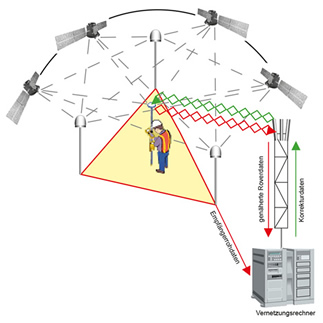
APOS stands for Austrian POsitioning Service and is the Multi-GNSS positioning service of the BEV - Federal Office of Metrology and Surveying. The GNSS signals (GPS, GLONASS and GALILEO) are processed and to improve the accuracy of the satellite based measurements the derived parameters are provided.
The cooperation with all neighbouring surveying authorities guarantees the involvement of many international GNSS reference stations close to the Austrian boundary. Thus APOS is the positioning service for Austria because it offers homogeneous 3D-coordinates in ETRS89 nation wide and across boundaries.
To the Point
You save time and costs - with APOS you are always one step ahead and more efficient. With the high performance and accuracy of APOS you will always have an efficient solution, wherever you want to determine your position.
- Direct connection to the network of control points
- High accuracy
- 3-D reference system
- Real time data transfer
- Access via Mobile Internet for cost-effective data transfer
- Nation wide homogeneous availability in ETRS89 or MGI
- High technical reliability
- Quality assurance
- Technical support
- Invoicing based on actual use

APOSition Yourself
Reliability and economic aspects are two reasons for the increased use of mobile positioning systems. APOS has proven itself a reliable partner in many areas and for many applications.
- Control, cadastral as well as scientific survey
- Agriculture and forestry
- Construction and engineering survey
- Airborne remote sensing
- Geological and geophysical survey
- GIS survey
- Stakeouts and routings
- Machine control