Cadastre and Land Register
Cadastre and land register together form the Austrian system of real estate protection. Both registers fall under the authority of the federal government and are accessible to the general public.
The cadastre is administered by Cadastral Offices and documents the current and objective situation of property as it relates to boundaries, location, size and use.
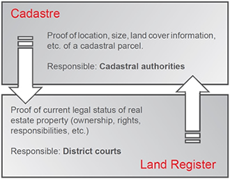
The land register is a public register of all real estate properties and is maintained by the district courts. The register records ownership as well as rights pertaining to, or charges upon real estate property.
Daily updating of cadastre and land register ensures that the data contained in the two registers correspond.
Cadastre and land register complement one another and are essential in maintaining Austria`s attractiveness as a location for business and investment.
Elements
The cadastre consists of technical documents, parcel register and address register.
Technical documents
- Technical documents to identify the control points and the boundaries of a parcel
- Technical documents that indicate the boundaries
- Cadastral map
- Business case register
Parcel register
- Parcel identifier
- Land cover an land use information
- Total area of parcel and area of each section of land cover information
- Other attributes of the property for ease of identification
- Miscellaneous notes
Address register
The address register contains all geocoded (spatial) addresses assigned by the responsible local authority to parcels and buildings.
Development
The boundaries of all parcels were originally surveyed (1817-65) to determine the amount of tax due on land. This is the origin of the term 'Property Tax Cadastre' .
A century later the degree of precision attained by these surveys no longer met modern requirements for the exact definition of boundaries.
The 1968 Survey Act (Vermessungsgesetz) introduced the legal 'Boundary Cadastre' (Grenzkataster). For the first time it became possible to secure the boundaries of a parcel with legally binding effect, and thus exclude the possibility of usucaption of parts of a parcel.
Boundary Cadastre and Property Tax Cadastre
The boundaries of parcels of land registered in the 'Boundary Cadastre' have boundary points with a degree of accuracy to centimeter-range, and are indicated in the cadastre accordingly. In addition, the surfaces are derived from boundary point coordinates with a high degree of precision. In the parcel register these are indicated by the surface indicators "*" or "rechnerisch" ('mathematical'). The entire boundaries of such parcels were established with the agreement of the owners of all neighboring parcels and are legally binding. Should a boundary marker be lost, the boundary may be marked out at any time by a licensed surveyor. The usucaption of parts of parcels is impossible. When title to such a parcel is acquired, the protection of legitimate expectation is thus assured.
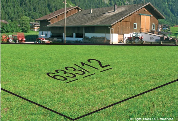
Parcels registered in the boundary cadastre are identified in the cadastral map by a broken line beneath the parcel identifier number; in the parcel register they are marked with "G".
Compared to surveyed boundaries, boundaries of parcels recorded in the Property Tax Cadastre are frequently represented in the cadastral map only with graphic accuracy. The degree of precision is in the range of decimeters or meters, and depends on the scale used in the 19th century cadastre.
The accuracy of boundaries of parcels established by surveying documents (subsequent surveys) is in the range of centimeters to decimeters. The values for area in the parcel register have a margin of error of 10% or more because they are in part determined graphically. The surface indicator is "graphisch" ( 'graphic' ).
In the case of parcels that were surveyed fully, the accuracy of the area indicated is significantly greater. The surface indicator in the Property Index is "*'" or "rechnerisch" ( 'mathematical' ).
The boundaries of parcels in the Property Tax Cadastre are not legally binding, and disputes may be brought to court.