Cadastral Map and Parcel Register
table of contents
Products
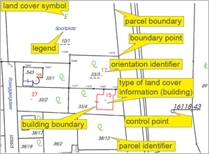
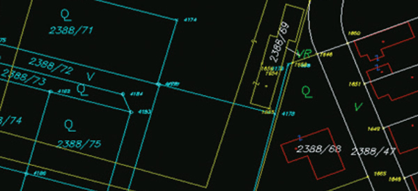
The cadastral map is the graphical data set contained in the cadastre in the coordinate system of the Austrian national topographic survey. The cadastral map is maintained by the responsible Cadastral Office. The map makes visible the location of parcels and includes:
- Parcel boundaries
- Parcel identifiers
- Land cover information and symbols
- Control points, boundary points and state boundaries points with their identifiers
- Other attributes
Parcel register
The parcel register contains the cadastre`s factual data and is maintained for each cadastral unit. It includes the following information for every parcel:
- Cadastral unit identifier
- Parcel identifier
- Type and sections of land cover information
- Additional legal information (if available)
- Area of each section of land cover information
- Yield figure
- Case identifier
- Register unit identifier
- Other information for ease of identification
Parcel register with owner
In addition to the parcel register described above, the parcel register with owner is provided. The register records the name, date of birth and address of the owners, as well as information concerning co-ownership shares for the relevant unit of the land register.
Parcel register by (land) register units
This parcel register includes, according to the defined area of interest, all parcels belonging to a specific (land) register unit. Correspondingly, the register with owner lists all data concerning owners.
Historical parcel register
This register reflects the cadastre status of a parcel as of a defined date.
Business case register
This register contains all cases related to a parcel. These are identified by case identifiers ('Geschäftsfallnummer ', GFN) and refer to files in the competent Cadastral Office, which resulted in changes being made to the cadastre. With its comprehensive listing of cases the business case register thus documents all changes affecting an individual parcel.
Boundary and state boundary points
This register includes all existing boundary and state boundary points of the defined area of interest.
Protocol of negotiations
This extract, which takes the form of a chronological listing of individual cadastre status, records all changes made to a parcel documented by a case identifier.
Preview layer
The preview layer provides a graphic representation of parcels based on a surveying document (plan) produced by a licensed surveyor, which are subject to possible future changes in the cadastre, prior to a ruling by the land registry and implementation in the cadastre.
Reference date data
At the beginning of every second and fourth calendar quarter current data from the parcel register, the cadastral map and ownership information are generated as key date data; this data is available for purchase three months thereafter. This graphic data (vector data) and attribute data (text) represent the legal status at the time they are generated. This data is adequate for a variety of uses, for example, overviews and large-scale planning. For uses pertaining to ownership, however, the latest data should be used.
Excerpt from the cadastral archives
Each change in the cadastre has been documented by means of a separate business case at the respective cadastral office since 1880. Basically the business case consists of a plan (public document) by a licensed surveyor. Before the plan (technical part) can be registered at the land register office and implemented in the cadastral map, it has to be certified by the respective cadastral office (exceptions for plans by the cadastral offices).
In the course of this registration process it is possible to add additional documents, which are not an integral part of the plan, to the business case. These than will be archived in the written part respectively in the papers about the boundary negotiation.
Until the 7th of May 2012 the business cases were stored in analog form at the archives of the cadastral offices as well as at the land register offices. Afterwards with the introduction of the Electronic Application the archives were digitized. All applications after this reference date can already be queried via the web. In 2013 we started to digitize, archive and provide in digital form all analogous documents of the cadastral offices. You find a status report on the homepage of the BEV under the top link "Digitalisierung Katasterarchive".
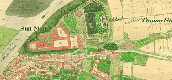
Historical cadastre original map
The original map of the "Franziszeischer Kataster" (Urmappe 1817 - 1861) was the first area wide capture of all parcels of the monarchy as it was then. The original plane table sheets on handmade paper with the format 53 cm x 66 cm are hand colored and mostly in the scale 1:2 880. The coloring was based on a uniform legend that defined the different types of land use and the fonts for the map sheets. For each cadastral community (fiscal community) there was a separate numbering of the parcels with or without buildings. Additionally there are sketches of the separate overviews which state the province (crown land), regional and fiscal district as well as the name of the community, in most cases also the neighboring communities. The original map is considered cultural heritage as stated by the Hague Convention.
Administrative boundaries
Administrative boundaries contain the boundaries of Austria`s administrative units in vector form. The accuracy of administrative boundaries that are coterminous with parcel boundaries corresponds to that of cadastral unit boundaries in the cadastral map. Generalized administrative boundaries are also available in 1:50 000 and 1:250 000 scale.

Information about regional units
Regional information is provided in the form of attribute data and offers comprehensive information about any specific administrative unit as of the 31st of December of every year. It contains legally relevant data as well as technical and statistical information.
Register of cadastral municipalities
This register is a list of all cadastral communities of Austria with the respective allocation to other administrative units.
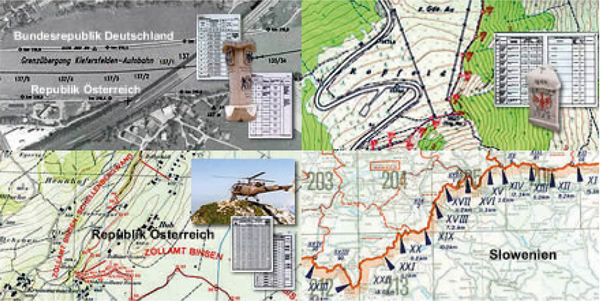
Documentation of the state boundary
The Austrian state boundary (without Lake Constance) is 2 706 km long and it is defined by about 27 000 boundary marks and about 40 000 unmarked break points. The course of the boundary was laid down in the respective state boundary treaties and partly runs straight from mark to mark and at other times along a broken line, defined by the above mentioned unmarked break points. Partly it also runs along natural (topographic) realities such as mountain ridges (watersheds) or along the middle of water bodies and there it mostly follows their natural changes and thus is flexible.
There are bilateral boundary treaties with all 8 neighboring states. These treaties comprise the course of the common boundary, its documentation and maintenance, as well as the tasks of the bilateral boundary commissions.
The boundary documentation consists of the following parts:
- Boundary map
- Boundary description
- Coordinate register (in the respective coordinate system)
- Other technical documents
Standard Charges
Analogue cadastral data
| Graphical data - standard and special edition | Price in € per sheet |
|---|---|
| Format A4 - PDF | 2,50 |
| Format A3 - PDF | 3,75 |
| Format A2 - PDF | 5,00 |
| Format A1 - PDF | 10,00 |
| Format A0 - PDF | 15,00 |
| With background for the whole section | 50 % surcharge |
| With background for selected objects | 25 % surcharge |
| Administrative data | Price in € per object |
|---|---|
| Parcel register format A4 - PDF | 0,03 |
| Parcel register with the list of owners/listed by entries format A4 - PDF |
0,06 |
| Business case register Format A4 - PDF | 0,03 |
| Historical digital parcel register Format A4 - PDF | 0,03 |
| Protocol of negotiations (boundary protocol) format A4 - PDF |
0,03 |
The minimum invoice amount per order item for administrative data in PDF is 2,50 EUR and for printouts 5,00 EUR.
Printouts are subject to a 100% surcharge, to be added to the PDF standard price.
Digital cadastral data
| Graphical data - raster | Price in € per km2 |
|---|---|
| Cadastre - graphical data | 10,00 |
| Graphical data - vector | Price in € per object |
|---|---|
| Cadastre - graphical data (all layers) | 0,100 |
| Parcel boundaries + parcel numbers, boundary points and boundary point numbers |
0,065 |
| Boundary of land cover + symbols of land cover, other lines, other symbols, other labels |
0,030 |
| Control points | 0,005 |
| Administrative data | Price in € per object |
| Parcel register | 0,020 |
| Parcel register with the list of owners/listed by entries* | 0,040 |
| Business case register | 0,020 |
| Boundary points and state boundary points | 0,015 |
| INSPIRE CP - cadastre parcels | 0,020 |
* The delivery of data (list of owners) is restricted by data protection conditions.
Digital cadastral data
| Preview layer | Price in € per object |
|---|---|
| Graphical data - vector* (all layers except control points) and open business cases |
0,100 |
* For reasons of data protection, preview layer data are available for concerned property owners, authorized surveyors and authorities only for execution of legal duties.
Reference date data
| Graphical data - vector | Price in € per object |
|---|---|
| Graphical data (all layers) | 0,010 |
| Administrative data | Price in € per object |
| Parcel register | 0,002 |
| Parcel register with the list of owners* | 0,004 |
* The delivery of data (list of owners) is restricted by data protection conditions.
Excerpt from the cadastral archives
| Business cases | Price in € per business case |
|---|---|
| Part A - technical part - archival surveying document - PDF | 0,80 |
| Part B - written part - PDF* | 2,50 |
| Part C - boundary negotiations protocol - PDF* | 2,50 |
| Part A - technical part - archival surveying document - print-out | 5,00 |
| Part B - cadastral document - print-out* | 5,00 |
| Part C - boundary negotiations protocol - print-out* | 5,00 |
* For reasons of data protection, these data are available for persons with a legitimate interest only.
Historical cadastre original map
| Reproduction of the original map | Price in € per sheet |
|---|---|
| Original map with page margin layout, map sheet division - PDF | 10,00 |
| Digital original map | Price in € per sheet |
| Original map with page margin layout, map sheet division | 15,00 |
Administrative units
| Administrative boundaries | Price in € per administrative unit |
|---|---|
| Administrative boundaries (accuracy based on parcel boundaries) | 0,20 |
| Administrative boundaries - reference date data | Price in € |
|---|---|
| Administrative boundaries (accuracy based on parcel boundaries) | Free of charge |
| Administrative boundaries 1:50 000 | Free of charge |
| Administrative boundaries 1:250 00 | Free of charge |
| Information about regional units | Price in € |
| Information about regional units | Free of charge |
| Register of cadastral municipalities | Price in € |
| Register of cadastral municipalities | Free of charge |
Documentation of Austrian state boundaries
| State boundary documentation | Price in € per sheet |
|---|---|
| Boundary description - PDF | 0,10 |
| Coordinate register - PDF | 0,10 |
| Map of state boundaries up to format A3 - PDF | 3,75 |
| Map of state boundaries larger than format A3 - PDF | 5,00 |
| Other technical documents up to format A3 - PDF | 3,75 |
| Other technical documents larger than format A3 - PDF | 5,00 |
Printouts are subject to a 100% surcharge, to be added to the PDF standard price.
Multi-user fee
| Number of authorised users | Multi-user fee factor |
|---|---|
| 1 to 5 | 1,00 |
| 6 to 25 | 1,25 |
| 26 to 100 | 1,50 |
| More than 100 | 2,00 |
| Group licence | 4,00 |
Minimum charge
For digital cadastral data, reference date data and the preview layer (graphical or administrative data) the minimum charge for each item ordered is 0,25 EUR.
Information as of February 2020
The standard charges are subject to change without prior notice.
General Terms and Conditions
Terms of delivery and payment and copyright notice requirements are contained in the currently valid General Terms and Conditions of the BEV.
Standard Fees and Terms of Use
Prices and terms of use of BEV products are set forth in the currently valid "Standardentgelte und Nutzungsbedingungen des BEV" (BEV Standard Fees and Terms of Use). The latest version which is published in the Amtsblatt für Vermessungswesen (Official Gazette for Surveying) can be accessed at www.bev.gv.at under the menu item "Preisinformationen".
Quality
The accuracy of the various types of cadastre definitions is summarized in the table below:
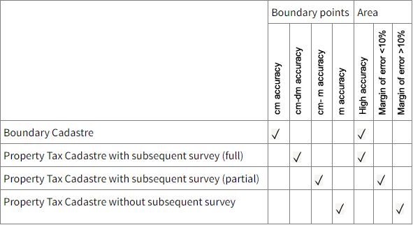
The individual parcels are registered either in the Boundary Cadastre or the Property Tax Cadastre, which are represented together in the cadastral map although they may reflect differences of quality.
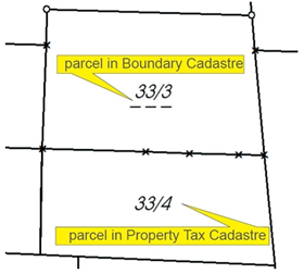
| Grundstücksnummer | G | Fläche [m2] | Flächenbestimmung |
| 33/3 | G | Gesamtfläche 607 | rechnerisch |
| 33/4 | Gesamtfläche 500 | grafisch |

Applications
The cadastre can be employed for a variety of purposes, for example:
- Zoning and development plans (regional planning)
- Municipal infrastructure projects (utility line cadastre)
- Environmental protection initiatives (tree cadastre, cadastre of contaminated sites)
- Objective area-based aid to agriculture (agricultural subsidies)
- Taxation (valuation)
- Public geographic and communal information systems of local authorities
- Application for building permits
- Boundary disputes
- Legal transactions
The locally responsible Cadastral Office will be pleased to assist you with all legal issues related to parcel boundaries. At the Cadastral Offices you will find the complete range of records and documents concerning all changes related to parcels, as well as competent partners ready to assist with advice and our products.
There are a number of ways to obtain cadastral data: Making purchases at our web shop is quick and convenient with the data you need made available by a download link. Another way is through a direct interface that permits access to cadastral data through BEV's online product service.
Order forms are also available for all our products.